
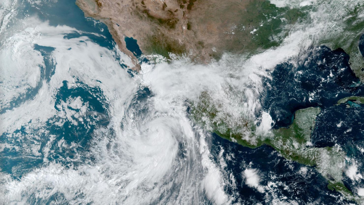
A strengthening hurricane tracking up Mexico’s Pacific Coast will affect Southern California’s weather by the weekend – all while delivering punishing rains and high winds to the Mexican coast through Friday.
The core of Hurricane Kay will be very near the west-central Baja California Peninsula, just after its peak intensity, on Thursday and Friday.
A hurricane watch is in effect for the west coast of the peninsula from Puerto Cortes to Punta Eugenia, according to the government of Mexico.
A tropical storm warning is in effect from Punta Abreojos southward to Cabo San Lucas and from Cabo San Lucas northward to Santa Rosalia, and a tropical storm watch is in effect from north of Santa Rosalia to Bahia De Los Angeles and from north of Punta Eugenia to San Jose De Las Palomas.
The storm will make its closest approach and perhaps make landfall on the central portion of the Peninsula late Thursday.
It is expected to turn west and weaken more after coming close to San Diego on Saturday.
The worst conditions are expected on the peninsula; however, the storm will still dictate the weather pattern for Southern California through the weekend.
Kay had sustained winds of 85 mph Tuesday evening and the center of the storm was located about 275 miles from the southern tip of the peninsula. The hurricane is expected to intensify as it travels northwest up the west coast of Mexico this week.
“Strengthening is forecast during the next 36 hours, and Kay could become a major hurricane during that time,” the National Hurricane Center said. “It should be noted that Kay is a fairly large hurricane with its tropical-storm-force winds (39 mph+) estimated to extend outward up to 175 miles from the center.”
These winds, surf and rainfall impacts will extend far from the center of Kay, the hurricane center warns.
Kay is expected to produce 4 to 8 inches of rainfall, with isolated storm total amounts of 12 inches, across portions of western Mexico through Thursday night. These rainfall amounts could lead to flash flooding, including landslides.
According to Mexico’s National Meteorological Service, the storm has already delivered torrential rains to Nayarit, Jalisco, Colima, Michoacan, Puebla and Oaxaca.
At least three people have died in the storm, the director of Guerrero state’s Civil Protection, Roberto Arroyo, said in an on-camera statement to Reuters on Sunday.
Kay’s exact impacts on Southern California are still somewhat questionable, but here are the possibilities.
Excessive heat warning extended
The punishing heat wave that has hit the western states is likely to ease in most of the West toward the end of the week, except in Southern California.
On Friday, Hurricane Kay will still be about 220 miles south of San Diego, the weather service in Los Angeles wrote, but the flow around the storm will bring easterly winds to the area, which could bring extreme heat all the way down to the beaches.

“It’s a complicated high temperature forecast for Friday for the coast and valleys,” the National Weather Service in San Diego said. “Strengthening east winds between high pressure to the north and the tropical system to the south bring downslope warming while moisture and clouds increasing from the south could offset the warming.”
The weather service in San Diego is extending the excessive heat warning for the region through Friday to account for the possibility of high temperatures well into the 90s to 100 reaching the coast on Friday.
In a similar fashion, the Los Angeles weather service office said its heat alerts also will likely need to be extended into Friday.
It isn’t just the daytime temperatures – Kay could keep temperatures warm through the overnights, too.
The easterly flow from Kay on Friday may well produce very warm overnights for the Los Angeles coasts and valleys, the weather service in Los Angeles said.
Through the weekend though, increased cloud cover as Kay nears will lead to lower temperatures.
“Look for 10 to 15 degrees of cooling on Saturday and a couple more on Sunday,” the LA office said.
“Beyond the heat that may occur for the coast and valleys on Friday, the increasing moisture will finally put an end to this long heat wave over the weekend with high temperatures not nearly as hot,” the San Diego Office said.
Kay is likely to bring inches of rain
“The eventual track of Hurricane Kay as it weakens also bears watching,” the WPC said Tuesday morning. “The eventual remnants of this storm will likely result in an increase in rainfall across southern California and Arizona by this weekend.”
“Precipitation could arrive along the east slopes of the mountains as early as Friday afternoon,” the weather service in San Diego said. “With increasing chances for precipitation across the entire area for the weekend.”
The WPC said a surge of increased moisture will likely arrive for the Desert Southwest, too. So, in its experimental forecast, the WPC issued a slight risk – level 2 of 4 – for excessive rainfall for portions of southeast California and southwest Arizona on Saturday.
Some computer forecast models hardly show any rainfall, while others show an extreme amount. The range in precipitation amounts is typical for a system this far away, the National Weather Service said.
So, “there is a possibility that this system will bring significant rainfall to portions of the area,” the Los Angeles NWS said.
The greatest potential for heavier rainfall is along the east slopes of the mountains, the San Diego office said.
In addition to the rainfall, strong winds and dangerous surf could impact the region, depending on how close the storm tracks to Southern California.
More will be known as the storm makes its way northwest.
CNN’s Taylor Ward, Monica Garrett and Hira Humayun contributed to this report