


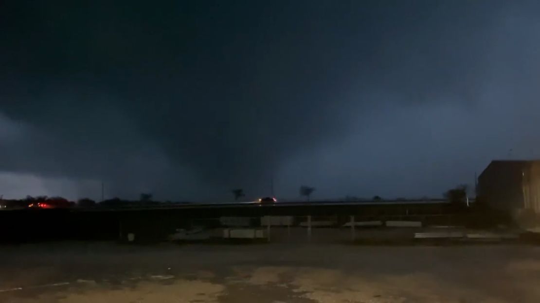
At least five tornadoes were confirmed in Texas during a storm outbreak Tuesday, according to the National Weather Service in Fort Worth.
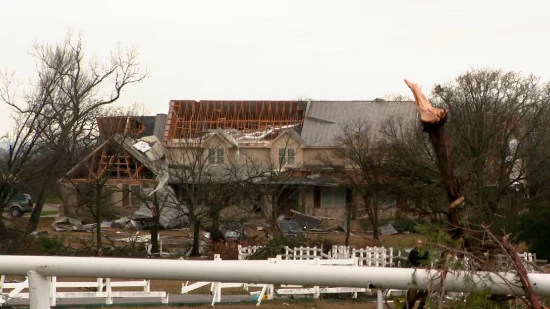
Three of the tornadoes were in Tarrant County, with the strongest having an EF-1 rating. One damage track was seen in the city of Grapevine, near the Dallas-Fort Worth International Airport.
The weather service said there was also an EF-2 tornado with 125 mph winds in Wise County, as well a tornado just west of the city of Paris. Damage surveys will be conducted in those communities Wednesday. Based on radar and damage reports, the National Weather Service said there could have been as many as 12 tornadoes in Texas Tuesday that they have not yet confirmed.
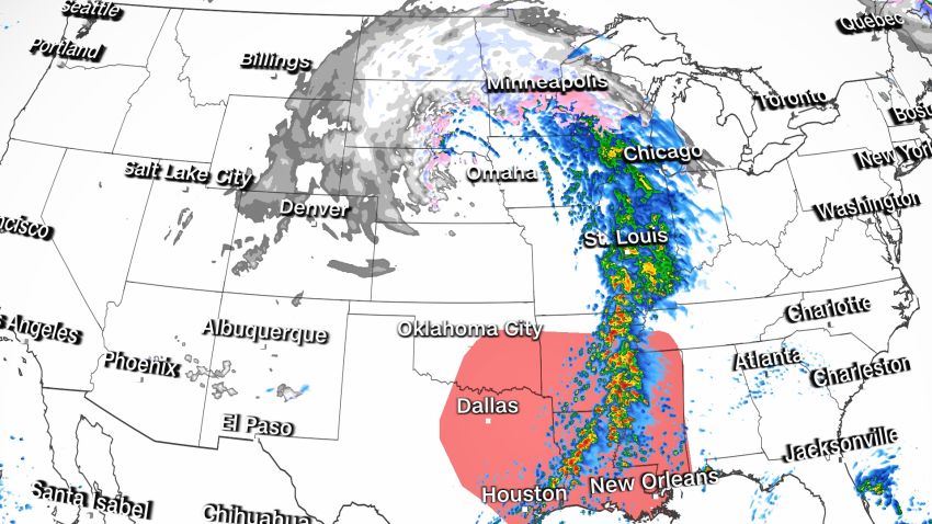
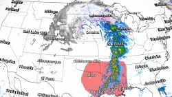
The storms have carved a path of destruction across Oklahoma and the Dallas-Fort Worth area Tuesday and injured at least seven people. They’re part of a larger storm system that threatens more damage in the South and blizzard conditions in states farther north.
The giant winter storm system is pushing through the central US after walloping the West. And about 10 million people – largely in the north-central US – are under winter-weather warnings or advisories Tuesday, with blowing snow and power outages a key concern.
A “one-in-five-year storm” worked its way through parts of Nebraska Tuesday and is expected to linger in the area through the end of the week, according to the NWS metrologist Bill Taylor. Blizzard warnings are in place throughout parts of the state and the state’s Department of Transportation said several roadways are closed, including all roadways from Nebraska into Colorado.
“If your destination is west, please delay those plans and adjust accordingly!” the department tweeted.
More than 18 million people from Texas to Mississippi are under threat of severe storms Tuesday, including tornadoes.
In Caddo Parish, Louisiana, which includes Shreveport, authorities are performing a search and rescue operation after a strong storm moved through Tuesday afternoon. The storms resulted in one woman being sent to the hospital and two people are currently missing, the Caddo Parish Sheriff’s Office said on their Facebook page.
“Several structures were damaged. Electrical lines and trees were also knocked down,” the sheriff’s office said. “Caddo deputies, K-9 teams, fireman, and volunteers are searching through debris and the area for the missing people. Caddo deputies continue to check the welfare of citizens from house to house.”
Authorities are “in search and rescue operations of a subdivision that contains approximately 40 homes,” Caddo Parish Sheriff’s Office Homeland Security Deputy Director Robert Jump tells CNN.
In a Facebook post Tuesday evening, the Caddo Parish Sheriff’s Office asked anyone concerned with missing people to contact their dispatch.

A tornado watch is in effect for northeast Louisiana, southwest Arkansas and western Mississippi until 2 a.m. CST, according to the Storm Prediction Center. This watch covers more than 1.5 million people and includes Shreveport and Alexandria, Louisiana.
“A few tornadoes and a couple intense tornadoes [are] possible,” the Storm Prediction Center said. Additionally, damaging winds up to 70 mph are also possible.
Damage on Tuesday includes:
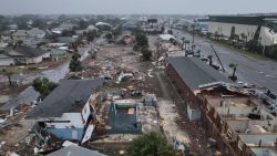
• Grapevine, Texas: At least one tornado was reported in this city just outside Dallas Tuesday morning, the National Weather Service said, and storms left at least five people there injured, Grapevine police said. Details about the injuries weren’t immediately available.
Businesses including a Grapevine mall, a Sam’s Club and a Walmart were damaged, police said. A gas station was destroyed, and drivers on one road were forced to share a single lane because downed trees and other debris blocked parts of the thoroughfare, motorist Claudio Ropain David told CNN.
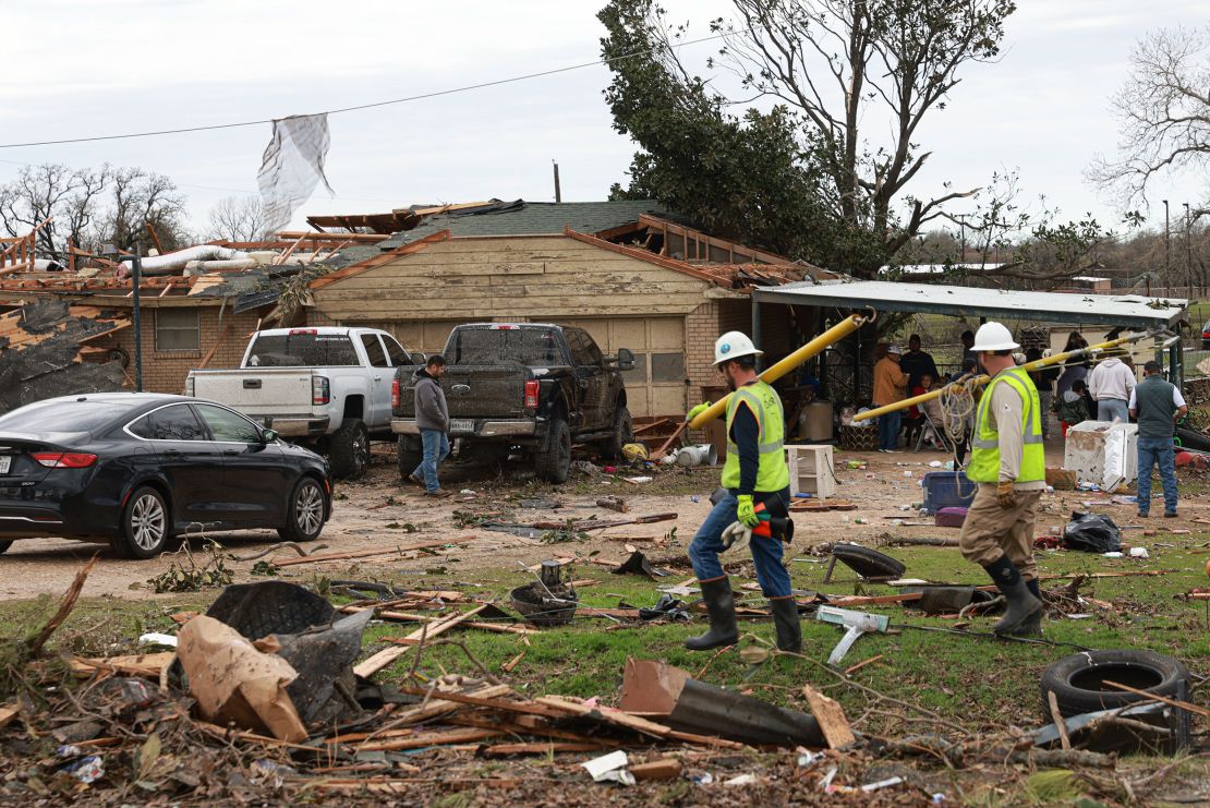
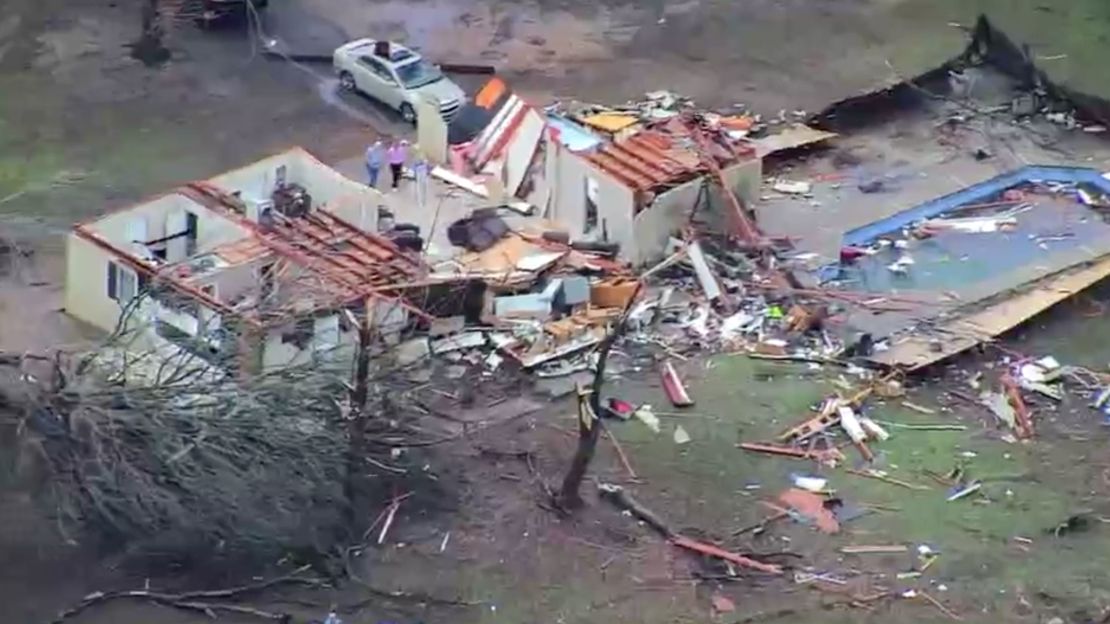
• Elsewhere outside Dallas: At least two people were injured, and homes and businesses were damaged, as severe weather hit east of Paradise and south of Decatur in Wise County on Tuesday morning, northwest of Fort Worth, county officials said.
One person was hurt when wind overturned their vehicle, and the other – also in a vehicle – was hurt by flying debris, the Wise County emergency management office said. One was taken to a hospital, the office said without elaborating.
High winds also damaged homes and trees near Callisburg north of Dallas, blew over tractor-trailers near the towns of Millsap and Weatherford; and damaged barns near the town of Jacksboro, the National Weather Service said.
• Wayne, Oklahoma: A confirmed EF2 tornado in that town knocked out power and damaged homes, outbuildings and barns early Tuesday, officials said, adding no injuries were reported. Homes were flattened or had roofs torn off, and trees were snapped like twigs, video from CNN affiliate KOCO showed.
The storm that rocked Wayne was on the ground for at least 3 miles with 120-125 mph winds, the National Weather Service in Norman, Oklahoma, said.
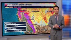
More severe storms capable of tornadoes, as well as hail and damaging winds are expected Tuesday and Wednesday in the Gulf Coast region as the complex snow-or-rain system sweeps through the central US from north to south.
Blizzard and ice warnings in the north-central US
Across the central and northern Plains and Upper Midwest, heavy, blowing snow and/or freezing rain into Thursday could snarl travel and threaten power outages.
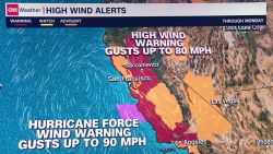
Blizzard warnings – forecasting at least three hours of sustained winds or frequent gusts at 35 mph or greater during considerable snowfall and poor visibility – extended Tuesday from parts of Montana and Wyoming into northeastern Colorado, western Nebraska and South Dakota.
Blizzard conditions were being reported in the morning and early afternoon near the Colorado-Kansas state line. Visibility along Interstate 70 in that area was down to 100 feet, a Kansas Highway Patrol spokesman said on Twitter.
Snowfall through Wednesday morning generally could be 10 to 18 inches in the central and northern Plains and Upper Midwest. Some areas inside the blizzard warning zones – particularly western South Dakota, eastern Wyoming and northwestern Nebraska – could get as many as 24 inches of snow, with winds strong enough to knock down tree limbs and cause power outages, the Weather Prediction Center said.
South Dakota Gov. Kristi Noem announced Tuesday that all state government executive branch offices statewide will be closed Tuesday due to the winter storm.
Most state offices in South Dakota will be closed again Wednesday and state workers who are normally in the offices affected will be working remotely, the governor’s office said.
State offices will be reopening Wednesday in 11 southeast counties that have less severe travel conditions.
“Officials continue to closely monitor the storm which features heavy snow, freezing rain, and high winds,” the governor’s office said. “A decision on state government office availability for Thursday will be made Wednesday.”
Parts of Wyoming have reported snow accumulations between 1 and 2 feet, according to the National Weather Service. The state’s Department of Transportation on Tuesday said wintry weather is impacting roadways throughout the entire state.
“Not a single green stretch of road in the state,” the department said in a Facebook post. “Strong winds, blowing snow, whiteout conditions and slick spots are impacting routes statewide (and in some neighboring states!)”

The Wyoming Highway Patrol also advised motorists to be aware of road conditions, as “many roads across Wyoming are currently closed due to crashes and winter conditions.”
In Sidney, Nebraska, winds whipped Tuesday morning at 53 mph, CNN meteorologist Chad Myers said, “and then you add in the snow, visibility is a quarter mile.”
Interstates in South Dakota could become impassable amid the blizzard conditions, resulting in roadway closures across the state, the South Dakota Department of Transportation warned Monday.
Ice storm warnings were issued for parts of eastern South Dakota. Up to two-tenths of an inch of ice could accumulate in some of these areas, forecasters said.
Wintry precipitation “will begin to spread eastward over the Upper Great Lakes late Tuesday and Wednesday and into the Northeast late Wednesday as the storm system continues eastward,” the prediction center said.
Freezing rain and sleet, meanwhile, will be possible through Wednesday in the Upper Midwest.
More tornadoes are a threat on the storm’s southern end
Meanwhile, the southern end of the storm threatens to bring more tornadoes.
Be prepared for severe weather and tornadoes
An alert for enhanced risk of severe weather – level 3 of 5 – was issued Tuesday for eastern Texas and the lower Mississippi River Valley, with the main threats including powerful tornadoes, damaging winds, and large hail. Baton Rouge, Shreveport, and Lafayette, Louisiana, are part of the threatened area, as is Jackson, Mississippi.
“My main concern with the tornadoes is going to be after dark,” Myers said Tuesday. “We have very short days this time of year, so 5 or 6 o’clock, it’s going to be dark out there. Spotters aren’t as accurate when it is dark. Tornado warnings are a little bit slow; if you’re sleeping, you may not get them. So, that’s the real danger with this storm.”
A zone of slight risk – level 2 of 5 – encircled that area, stretching from eastern Texas and southern Oklahoma to southern Arkansas and much of the rest of Louisiana, including New Orleans, and central Mississippi.
Tuesday also brings a slight risk of excessive rainfall in parts of Arkansas, Louisiana and Mississippi, with 2 to 4 inches of rain and flash flooding possible, the Weather Prediction Center said.
On Wednesday, the threat for severe weather is largely focused on the Gulf Coast, with tornadoes and damaging winds possible over parts of southern Louisiana, Mississippi, southwest Alabama and the western Florida Panhandle, the Storm Prediction Center said.
In Mississippi, the Meridian Public School District – which serves over 4,900 students – announced they will be closed Wednesday due to the threat of severe weather. Meridian is about 86 miles east of Jackson.
“All schools, offices, and departments in the Meridian Public School District will be closed on Wednesday, December 14, 2022, due to the threat of 70 mph winds and possible tornadoes throughout the day on Wednesday, December 14, 2022. All extracurricular activities and practices are also canceled for December 14, 2022,” the school district said in a message on Facebook.
The Lawrence County and McComb School Districts also announced they were closing Wednesday due to the threat of severe weather.
The Mississippi Emergency Management Agency also noted the severe weather expected in the state and asked residents to prepare.
“With severe weather expected throughout Mississippi tonight and tomorrow, please review your severe weather preparedness checklist to make sure you are ready for the storms,” the agency said in a message on Twitter.
CNN’s Taylor Ward, Andy Rose, Paradise Afshar, Rebekah Riess, Derek Van Dam, Dave Hennen, Michelle Krupa, Nouran Salahieh, Rob Shackelford, Joe Sutton and Melissa Alonso contributed to this report.